Home\Our Services
Our Services
Air Quality Monitoring and Strategies
Environment Arabia specializes in air quality monitoring and the development of air quality strategies in accordance with environmental standards. Our comprehensive approach combines state-of-the-art monitoring technologies with expert data analysis to deliver accurate assessments of air pollutant levels across various settings. Whether you are navigating regulatory requirements, conducting environmental impact assessments, or enhancing public health initiatives, our services provide essential insights and actionable strategies. We offer customizable monitoring plans, real-time data visualization, and advanced modelling capabilities to support informed decision-making and proactive environmental management.
Air Dispersion Modelling
Environment Arabia offers comprehensive air dispersion modelling services designed to support environmental management and regulatory compliance. Our expertise in air dispersion modelling enables us to simulate the transport and dispersion of pollutants from various sources, including industrial facilities, transportation networks, and other emission points. Using advanced modelling software and innovative methodologies, we deliver precise predictions and actionable insights. Whether you need modelling for environmental impact assessments, permit applications, or operational planning, Environment Arabia offers reliable solutions designed to help you make informed decisions and mitigate environmental impacts effectively.
GHG Footprint & Assessments
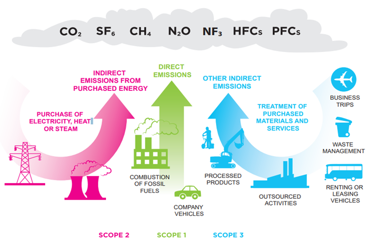
Environment Arabia specializes in conducting Greenhouse Gas (GHG) footprint assessments to help organizations measure, manage, and mitigate their carbon emissions. Our comprehensive services support businesses in understanding their environmental impact, complying with regulatory requirements, and aligning with international standards. We analyse scopes 1, 2, and 3 emissions—covering both direct and indirect emissions—using robust methodologies and industry-specific emission factors to ensure accurate data. Additionally, we offer strategic guidance on developing decarbonization strategies, GHG reduction strategies, implementing sustainable practices, enhancing energy efficiency, and exploring opportunities for renewable energy adoption and carbon offsetting.
Remote Sensing & Habitat Mapping
Environment Arabia leverages cutting-edge remote sensing technologies to provide advanced environmental monitoring and assessment solutions, collecting and analysing data from a variety of sources including satellites, radar, marine technology, drones, and aerial surveys.
Our remote sensing services cater to a wide range of applications, utilizing sophisticated image processing techniques and GIS analysis to deliver accurate and actionable information that supports informed decision-making.
Environment Arabia specializes in integrating remote sensing data with ground-based measurements and environmental modelling to enhance the understanding of complex environmental processes. Whether you need monitoring for forestry, agriculture, water resources, or urban planning, our customized solutions are designed to meet your specific needs and regulatory requirements.
Marine Environmental Surveys & Services
Environment Arabia offers comprehensive marine survey services supported by a full array of state-of-the-art equipment and three survey vessels located within the Kingdom of Bahrain.
Our core work includes the collection of scientifically robust baseline data, used to support EIA, in addition to short and long-term monitoring programmes.
Our clients include both government and private sectors associated with some of the largest projects in the Middle East.
We offer services within four key sectors including: Scientific SCUBA diving; Remote video surveys; Environmental sampling and Intertidal surveys.
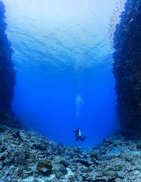
Scientific Diving
All diving work is led by an HSE (UK) scientific diver to ensure compliance with robust safety standards.
Photography is key to our work, and we operate a diverse array of digital cameras with external lighting packages.
Scientific SCUBA diving facilitates the collection of:
- Ecological data (e.g. coral reef, seagrass and fish communities, sampling of sediments/ biological specimens) via standardised scientific protocol (e.g. Regional Organization for the Conservation of the Environment of the Red Sea and Gulf of Aden (PERSGA) and Gulf Rapid Reef Assessment (AGGRA)).
- The installation of our recording devices (e.g. Acoustic Doppler Current Profilers (ADCP), water quality loggers, Baited Remote Underwater Video (BRUV)).
Remotely Video Surveys
Where the use of SCUBA is not viable (e.g. within working ports, deep waters or where there are significant HSE risks), we can undertake assessment of seafloor habitats and benthic communities using remote techniques in water extending to 300 m depth.
Environment Arabia owns and operates various systems, including a Remote Operated Vehicle (ROV) and Drop-Down Video (DDV) cameras.
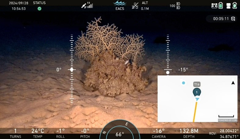
All our systems record in High Definition (HD), or 4k, and provide both still and video footage. Our DeepTrekker Pivot ROV is fitted with both USBL and DVL tracking and navigation systems and our DDV system overlays positioning data (e.g. GPS coordinates) on all footage. To facilitate data collection our systems, incorporate external lighting, laser pointers (to assist in scaling) and quadrats for the quantitative assessment of seafloor communities.
Environmental Sampling
Environment Arabia can conduct ex situ and in situ sampling of marine waters and sediments conforming to strict sample preservation and holding times. Sampling is conducted to support marine environmental baseline assessment with regards chemical, physical and biological (e.g. macro benthos) disciplines. Environment Arabia works with several accredited laboratories within the Arabian Peninsula to ensure a high standard of quality control.
Sediment sampling
Samples are collected via the use of a hand operated Van-Veen grab or sediment corer (e.g. for subsequent analysis of below ground carbon storage), processed on site where necessary (e.g. sieved for macrobenthos). Samples are sent to relevant laboratories for subsequent analysis.
Water sampling/measurements
Water samples are collected using delayed sampling devices (i.e. Niskin, Van Dorn, various mesh sized plankton nets and associated flow meters). Samples are, where relevant (e.g. plankton) processed onsite, and sent to relevant laboratories for subsequent analysis.
In situ measurements of key parameters (i.e. pH, salinity, dissolved oxygen, turbidity, temperature) are undertaken using our YSI PRO DSS multiparameter measuring sonde. In vivo chlorophyll a measurements are recorded using a Turner Designs AquaFluor meter.
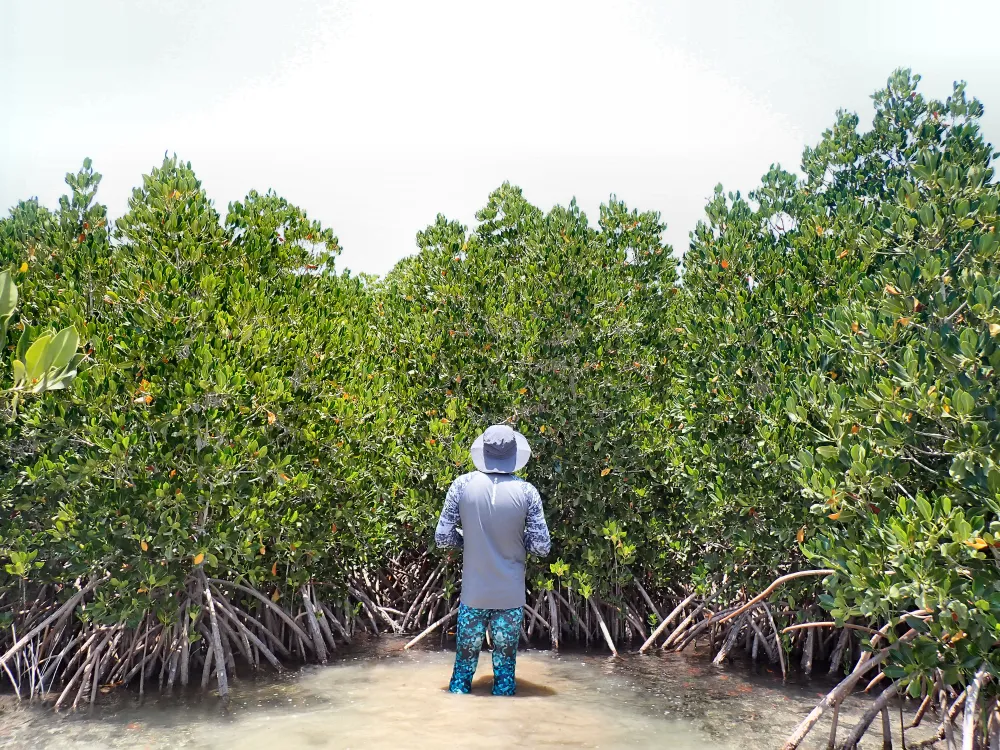
Intertidal Surveys
Environment Arabia can provide a full range of surveys including detailed shoreline and mangrove assessment.
We adopt internationally recognised methodologies including Kauffman & Donato, 2012 and, PERSGA, 2019 and supported by specialised equipment including transects, box corers and aerial imagery (e.g. satellite and drone).
Key to our surveys is the assessment of turtle nesting and avifauna.
Artificial Reefs
Together with our sister company, Reef Arabia, we manage the complete life cycle (i.e. design, site selection, and monitoring) of habitat restoration and enhancement via the use of artificial reefs. As an authorised ReefBalI™ contractor, Reef Arabia can supply a diverse array of ReefBall™ units in addition to their own bespoke and patented units (e.g. Majfara, Seamount and Jebel) ..
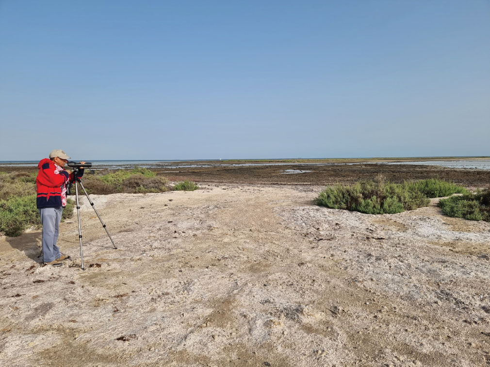
Terrestrial Ecology & Avifauna Surveys
Environment Arabia conducts comprehensive assessments of terrestrial ecosystems and bird populations. Our surveys are designed to gather data on biodiversity, habitat quality and species distribution, utilizing a multidisciplinary approach that integrates field surveys, GIS technology, and statistical analysis to provide valuable insights for conservation and management planning. Whether assessing habitat suitability for endangered species or monitoring ecosystem health, our team is committed to delivering scientifically sound assessments that support informed decision-making and sustainable environmental practices.
Contaminated Land Investigation & Remediation
Environment Arabia specializes in providing comprehensive services tailored to assess and mitigate environmental risks associated with contaminated sites. Our expert team utilizes techniques and equipment to conduct thorough investigations, identifying contaminants and assessing their impact on soil and groundwater quality in-line with industry’s best practices and standards. We offer a full spectrum of remediation strategies, tailored to meet regulatory requirements and ensure site sustainability. Whether you are dealing with historic industrial pollution, brownfield redevelopment, or compliance with environmental standards, Environment Arabia delivers reliable solutions to restore environmental integrity and support sustainable development goals.
Groundwater Monitoring
Our expertise in groundwater monitoring encompasses a range of industries including oil and gas, industrial facilities, and residential developments. Using monitoring equipment and techniques, we conduct regular assessments to track groundwater levels, assess contamination risks, and ensure compliance with regulatory standards. Our tailored groundwater monitoring programs are designed to detect changes in water quality over time, providing early warning indicators of potential environmental impacts. Whether you require routine monitoring, environmental impact assessments, or groundwater remediation support, Environment Arabia provides reliable solutions to protect groundwater resources and promote sustainable practices.
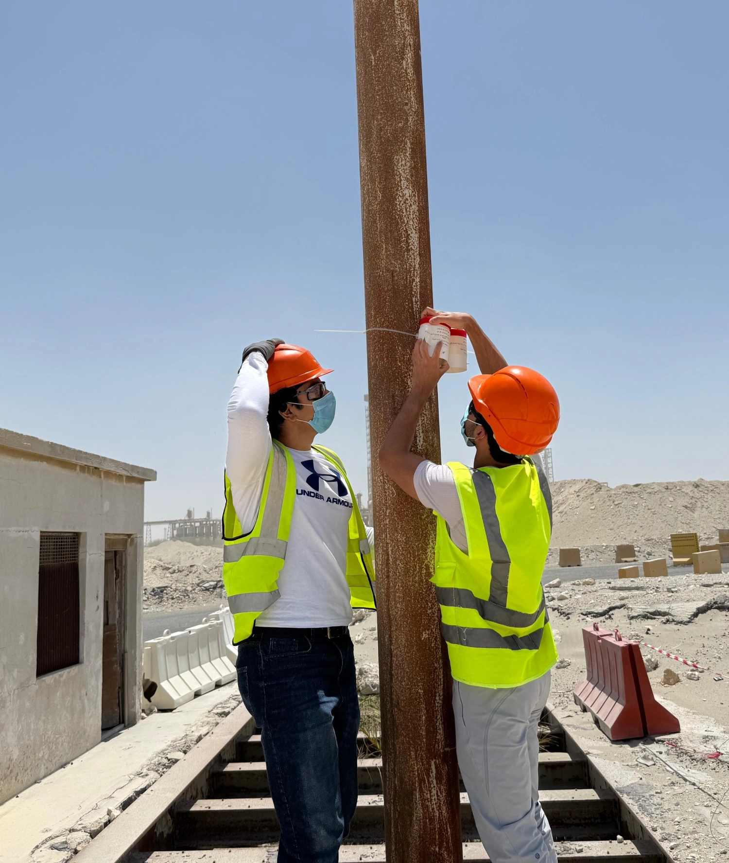
NORM Baseline Surveys
Environment Arabia specializes in conducting baseline Naturally Occurring Radioactive Materials (NORM) surveys, encompassing the measurement of gamma exposure and levels of alpha and beta contamination. These surveys serve as foundational data for developing NORM Management Plans, essential for mitigating risks, and devising effective radioactive waste management solutions.
Noise Monitoring & Modelling
Environment Arabia offers comprehensive noise monitoring and modelling solutions tailored to meet regulatory requirements and environmental standards. Our noise monitoring services utilize advanced equipment to measure and analyse noise levels accurately, conducting detailed assessments to identify sources of noise, evaluate potential impacts on surrounding communities, and recommend mitigation measures to minimize disturbance.
Our expertise extends to noise modelling, utilizing various software to simulate noise propagation and predict potential impacts in different scenarios. This helps clients assess the effectiveness of noise control measures and optimize project designs to meet noise criteria and regulatory limits.
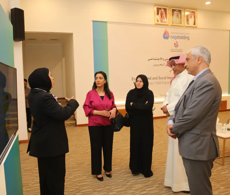
Stakeholder Engagement Plans & Public Disclosure Support
Stakeholder engagement is essential in environmental impact assessment and policy development, mandated both by local environmental regulators and external financing entities. Environment Arabia specializes in drafting comprehensive stakeholder engagement plans, essential for major projects, and participates in public disclosure meetings. Environment Arabia is committed to facilitating constructive dialogue and promoting sustainable practices through effective stakeholder engagement and public disclosure initiatives.
ESG Policies
Environment Arabia is experienced in developing Environmental Social Governance (ESG) policies and procedures tailored to meet the evolving needs of businesses and organizations. Our expertise lies in crafting robust frameworks that integrate environmental stewardship, social responsibility, and corporate governance into core business strategies. We collaborate closely with clients to assess their specific ESG requirements, conduct comprehensive stakeholder consultations, and align policies with international standards and best practices. Whether you are navigating regulatory requirements, enhancing stakeholder engagement, or seeking to improve transparency and accountability, Environment Arabia provides strategic guidance and implementation support to help you achieve your ESG objectives effectively.